When it rains, it pours with climate change
“When it rains, it pours” has become a reality for our weather in a changing climate. Let’s take a closer look at climate change and rainfall, and the impacts on people and places in the UK and around the world.
How are rising global temperatures affecting rainfall in the UK?
Human actions have emitted over 2500Gt of carbon dioxide into the atmosphere since the 1800s, mainly due to burning fossil fuels, and deforestation. This has enhanced the greenhouse effect and warmed the planet by around 1.4°C, and the UK by about 1.7°C.
Climate change isn’t just about rising temperatures. It might not sound a lot, but for every 1°C temperature rise our atmosphere can hold 7% more moisture. This increase in atmospheric water content leads to heavier rainfall. So it’s not surprising to know that today’s rainy weather is different to the rainy weather of the past.
The UK’s rainfall is strongly influenced by natural variability, with atmospheric circulation patterns of the North Atlantic and European regions driving the rainfall we experience.
But, the effect of climate change is also clear. In the UK, rainfall intensity (how heavy it is when it rains) has increased by 16% since 1891, in all seasons, and the effect of climate change is larger in winter than in summer. Six of the UK’s ten wettest winters since records began nearly 250 years ago have been this century.
How is climate change affecting rainfall around the world?
Climate change is also reshaping rainfall patterns worldwide. Some areas are becoming wetter with more intense rain events, others are becoming drier, and many regions are seeing greater rainfall variability and extreme weather.
While global warming is increasing rainfall, it is not happening evenly – with some strong regional contrasts:
- Europe is experiencing more frequent and intense heavy rainfall events, especially in northern and central regions. Some southern European areas are trending toward drier conditions.
- Some parts of Africa are facing more intense monsoon rainfall, whereas others are experiencing increased drought risk.
- Stronger monsoons and heavier seasonal rains are expected for southern and eastern parts of Asia.
- More intense rainfall observed across eastern and central parts of North America, and stronger rainfall in the tropical regions of South America.
- Australia’s rainfall is varying strongly by region, with the northern area staying wet and the southern area getting dry.
- Polar regions remain dry overall but are experiencing more snowfall and shifting precipitation patterns.
- The tropics remain the world’s wettest band, with rainfall projected to become more extreme.
What are the impacts of more intense rainfall?
Heavy downpours linked to climate change are making UK winters wetter and flooding more likely. More intense rainfall could lead to:
- More excess water moving across ground into streams, rivers, and oceans when the soil is saturated or impervious.
- Higher peak flows in streams and rivers, where the maximum volume of water passing through is greater than usual.
- Increased flood risk as streams, rivers, drainage networks, sewerage systems, and coastal waters overflow.
- Damage to or failure of infrastructure like roads, train lines, bridges, power grids.
- Environmental destruction through soil erosion, landslides, and nutrient pollution.
- Economic losses from property damage, ruined crops, and disrupted work.
- Physical health risks from flash floods, disease transmission from contaminated drinking water, and mental health issues in flood survivors and displaced people.
The impacts of more intense rainfall on people and places can be complex though. The conditions of soils and the storage capacity of groundwater and reservoirs, plus floodplain development and river engineering, can influence the risk of flooding across different parts of the UK.
It’s important for weather and climate scientists to work alongside the decision-makers who can take action to tackle the threats posed by heavy rains and floods.
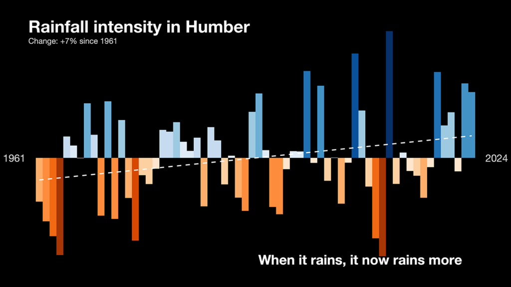
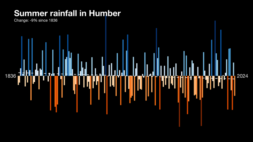
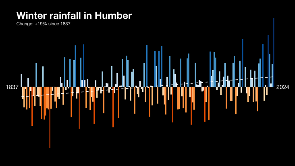
UK case study: Rainfall intensity in the Humber region
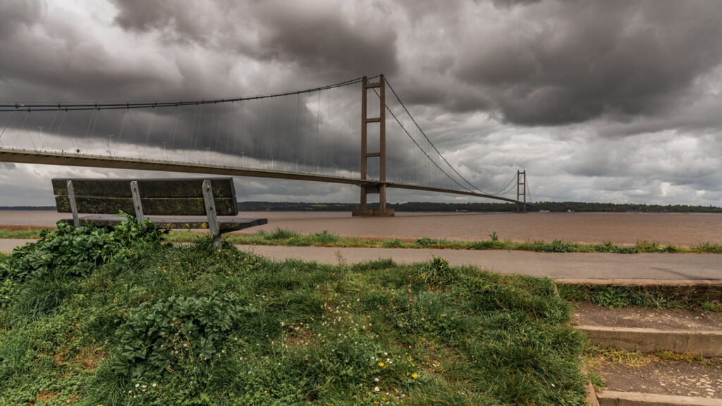
The Humber is a significant tidal estuary (64km long) on England’s east coast, formed where the Rivers Ouse and Trent meet before flowing into the North Sea.
Serving as a natural divide between the East Riding of Yorkshire and North Lincolnshire, it functions as a vital maritime corridor, home to the nation’s largest port complex, and an important habitat for diverse wildlife. It also represents one of the three major subdivisions of Northern England, alongside the North West and North East regions.
Climate scientist, Professor Ed Hawkins, created 3 climate data graphics for the Humber to show the changes to rainfall intensity in the region, during summer and winter.
Rainfall records show a 7% increase in rainfall intensity over the last 6 decades. For people living, working, and visiting the region – when it rains, it now rains more on average than it used to.
In summertime, rainfall in the Humber has decreased with climate change by 9% since 1836. But in winter months, Humber region rainfall has increased by 19% over the same time period.
The effect of climate change on rain in the Humber region is larger in winter than in summer, with important consequences for river flows, estuary levels, local infrastructure, economic activities, and the natural environment.