
Why do mountains matter for weather forecasts?
Scientists are embarking on a groundbreaking observational campaign to investigate atmospheric processes over mountainous terrains, to improve the accuracy of weather forecasts.
We spoke to researchers from the National Centre for Atmospheric Science involved in the TEAMx programme about why mountains matter in forecasting weather, and how they are collecting new data with radiosondes, radar, research aircraft, and bespoke scientific instruments.
How do mountains impact weather and climate?
About one third of the Earth’s land surface is made up of mountains, hills, and other elevated terrain. Mountains have a big impact on local weather, regional weather patterns, and airflow in the lower and upper atmosphere.
If you were to imagine the Earth at a size so it could sit comfortably in the palm of your hand, its surface would be as smooth as a snooker ball, and the surrounding atmosphere would be barely noticeable. In reality though, our planet’s surface is rough and bumpy, with mountains directing or blocking air and launching “waves” into the relatively thin layer of the atmosphere.
Dr Charles Chemel, research scientist at the National Centre for Atmospheric Science (NCAS) and University of Leeds
Dr Charles Chemel, research scientist at the National Centre for Atmospheric Science (NCAS) and University of Leeds explains the main ways that mountains impact weather:
“When moist air encounters a mountain, it’s forced upward. As it rises, it cools and condenses, forming clouds and precipitation. This is known as orographic lift, and is why the windward side of a mountain range gets more rainfall. Mountains can block or redirect storm systems, and have the power to enhance thunderstorms by forcing warm, moist air to rise much quicker than it would over flatter ground. They can also create a rain shadow effect. After air rises and loses moisture, it then descends on the leeward side (opposite side) of the mountain where it warms up and dries out.
“Deep temperature inversions are created by mountains, as cool air can get trapped under a layer of warm air in the valleys between peaks, and can persist for several days. Temperature inversions prevent the mixing of air and can lead to fog, frost, and air pollution build-up. Mountain passes can also funnel and accelerate winds, leading to strong gusts, and areas rapidly warming or cooling.”
He outlines how mountains impact regional and global atmospheric conditions too:
“Mountains alter large-scale air flow and condition climate patterns that lead to droughts and storms. Let’s think about some of the most iconic mountain regions of the world. The Himalayas block cold air from Siberia, keeping South Asia warmer in winter. The Indian Monsoon is also shaped by the Himalayas, which trap moist air from the Indian Ocean, leading to heavy seasonal rains.
“The Rocky Mountains influence the jet stream, sometimes causing weather extremes in North America. The Andes, Sierra Nevada, and Cascades contribute to the deserts of Atacama, Nevada, and eastern Oregon by blocking moist air or via the rain shadow effect.
“Mountain ranges influence how air masses interact with oceans too, affecting currents like the Gulf Stream and El Niño-Southern Oscillation. Large mountain glaciers reflect sunlight, in turn regulating regional and even global temperatures, but melting glaciers due to climate change could disrupt this.”
How are scientists observing the atmosphere in mountain regions?
It’s clear that mountains are important to meteorologists and climate scientists. But interactions between mountains and the air around them, at a range of spatial and temporal scales, are a large source of error in forecasting models. Why? Because there are gaps in data to develop models, mountain regions are typically undersampled, and the models don’t represent them to a high enough resolution.
Dr Charles Chemel, research scientist at the National Centre for Atmospheric Science and University of Leeds
The NCAS-led part of the TEAMx (Multi-scale Transport and Exchange Processes in the Atmosphere over Mountains) programme sets out to address the shortage of mountain weather data. Their focus over the next year will be the Alps, a mountain range that stretches across 8 countries in Europe.
Joining an international team of 100+ fieldwork scientists, NCAS staff will be instrumental in the TEAMx project by developing and deploying bespoke research-grade instrumentation into the alpine environment, launching paired radiosondes, installing a new X-band weather radar on a mountain crest, and operating our research aircraft. From the ground, and by taking to the skies, NCAS researchers and our scientific infrastructure will equip modellers with essential data.
Investigating gravity waves with weather balloons
Dr Phil Rosenberg, an instrument scientist and researcher at NCAS and the University of Leeds explains how weather balloons are collecting data about gravity waves for TEAMx:
“We’re interested in how mountains create gravity waves. As winds blow over a mountain, air is pushed up one side, then down the other. This disturbance causes a ripple in the atmosphere, a bit like the ripple on a pond, and the air continues to move up and down as it travels downwind. These ripples, known as gravity waves, can affect our weather and cause hazards for aircraft, but our weather forecasting simulations are not very good at predicting how strong they will be.
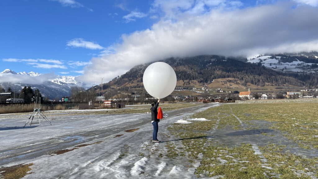
“We can’t study how mountains affect the weather by just measuring what’s going on at ground level, we need to measure up to and beyond the mountain peaks. We do this by releasing helium-filled weather balloons that carry a set of sensors called a radiosonde. As the balloon rises we measure temperature, humidity, pressure and wind – and the live data is transmitted via radio back to our team on the ground.
“The balloon expands as it rises, starting out just under a metre across when we release it, then by the time it reaches 30 km altitude it has expanded to 4 metres – that’s about as big as an elephant. Around this size the balloon can’t stretch any further and it pops, with the sensors floating back down to earth on a parachute. 30 km is about 3.5 times the height of Everest and more than 6 times higher than Mont Blanc.
“We’re doing something fairly unique by releasing two weather balloons at once. The data from these sensors will tell us if cold air is pooling in a valley, whether the air is blowing over or around a mountain, and the strength and direction of the wind perturbations generated by gravity waves. By analysing the way the balloons drift apart and the differences between their measurements we can get extra information about the size of the gravity waves we are investigating. Often the gravity waves occur at night, so our TEAMx team has been releasing weather balloons round the clock!”
Deploying mountain-top weather radar
Dr Lindsay Bennett, a radar instrument scientist at NCAS and the University of Leeds explains how TEAMx will use a state-of-the-art moveable weather radar:
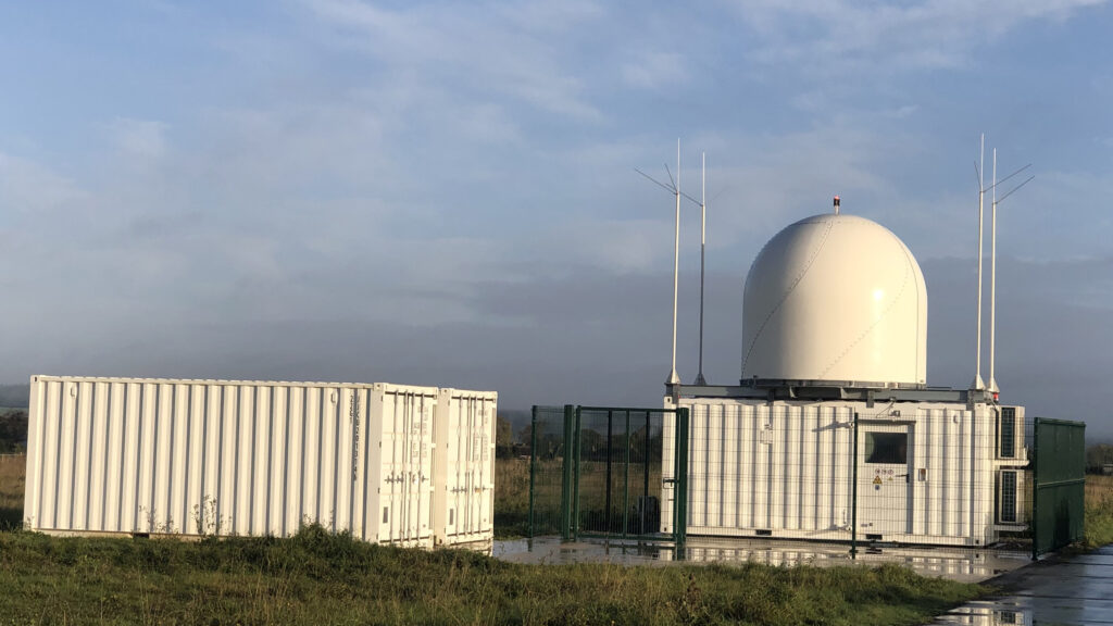
“Weather radars are the most effective way to collect real-time rainfall and cloud information. NCAS operates a moveable weather radar, known as NXPol-2, which operates at X-band frequency – this is a shorter wavelength suitable for close-range observations of clouds within 150km. It is also a dual-polarisation radar, which means it transmits two pulses of radio waves simultaneously, perpendicular to each other, which enables both the size and shape of particles to be determined from the reflected waves.
“One of NXPol-2 unique strengths lies in its portability, which means it can collect highly detailed information in regions where stationary radars cannot reach, or cannot be permanently installed. The radar is equipped with a large outer shield – known as a radome – that means the radar can operate during high winds. Under cover of the radome, the radar can also be accessed for repair and maintenance while staying protected from the weather.
“We can deploy the NXPol-2 in harsh environments as it’s much more robust than other weather radars we’ve used before. For TEAMx, we will install the NXPol-2 on top of Mount Plose at an altitude of 2486m, and it will observe clouds and thunderstorms as they develop over the Sarntal Alps region.
“Scans from our radar will be synchronised with two others – a similar portable X-band system on Mount Rittner Horn deployed by the Karlsruhe Institute of Technology specifically for TEAMx, and one on Mount Macaion that is part of the Italian National Meteorological Agency’s network. By combining measurements from multiple radars we can calculate two-dimensional wind fields and investigate how that controls the initiation and development of clouds over the higher terrain, and where the heaviest rainfall occurs.”
Coordinating research aircraft flights
Doug Anderson, a research aircraft deployment specialist, outlines how the FAAM Airborne Laboratory’s research aircraft will take to the skies this summer for TEAMx:“In early July, the aircraft will depart its home base in Cranfield to Innsbruck in Austria for just under 4 weeks of science flights. After setting up a flight operations centre and organising equipment and tools, the airborne science team will complete one or two flights almost everyday for 25 days.
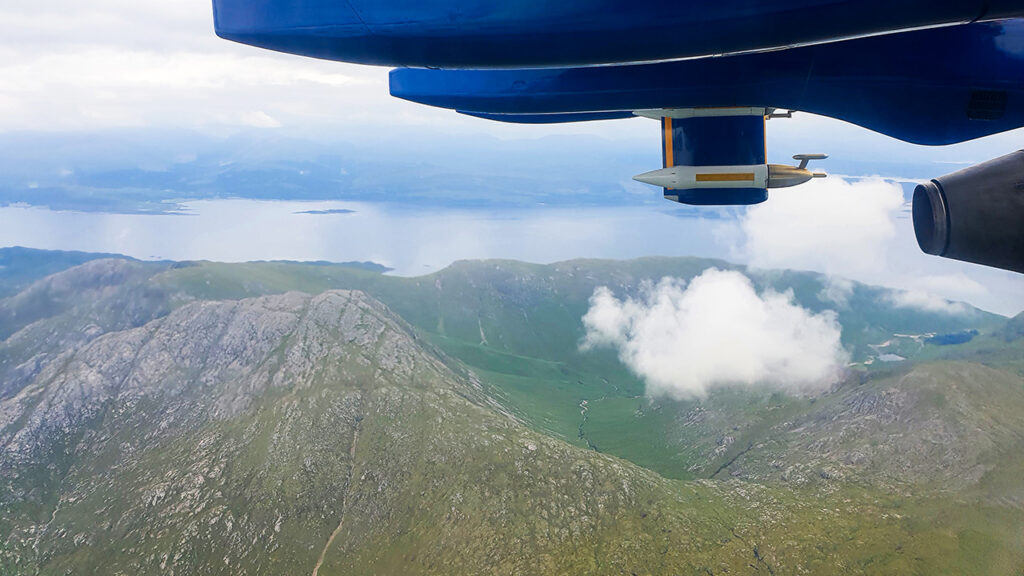
“Some of these flights will be coordinated with measurements taking place on the ground, and two smaller research aircraft. The DLR research aircraft Cessna 208 B Grand Caravan will fly at low level, the TUBS Cessna F406 Caravan II will fly at low-mid level, and our large and highly-modified BAe-146 four-engined jet will fly above both.
“One of the airborne activities will involve deploying dropsondes every 45 seconds – to complement the radiosondes carried by weather balloons from the ground. The aircraft travels at 100 metres per second, so each dropsonde will be roughly 4 kilometres apart.
“A dropsonde is a weather instrument designed to be released with a parachute from an aircraft to collect atmospheric data as it descends. It is equipped with sensors that measure temperature, humidity, pressure, wind speed, and wind direction at different altitudes. The data is transmitted in real time back to the aircraft.”
Beyond observational data collection, atmospheric modelling techniques for complex terrains will be refined – not only for weather forecasts, but for climate predictions too.
Further information
The success of TEAMx will be built upon a robust network of international partners, including NCAS, highlighting the global commitment to advancing meteorological research in mountainous regions. Find out more about TEAMx.